Outline
- Why are intersections of paramount importance in the realm of road safety?
- Redefining Road Safety: Behavior-Based vs. Crash Data-Centric Approach
- Unveiling the Methodology: Severe Braking Events as a Key Indicator
- Three of the Most Dangerous Intersections in Miami-Dade County
- Embracing the Future of Road Safety
In the United States, intersections have long been recognized as hotspots for traffic crashes. According to data from the Federal Highway Administration (FHWA), more than 50% of crashes and 1 in 4 traffic fatalities occur at these junctures, making them critical areas for evaluation and intervention.
Our revolutionary approach at Michelin Mobility Intelligence leverages driving behavior-based insights to meticulously assess, prioritize, and evaluate the risk associated with intersections. This innovative methodology is not merely a supplement to the conventional reliance on historical crash data; it is a fundamental shift in how we approach road safety.
Why are intersections of paramount importance in the realm of road safety?
Intersections serve as epicenters of potential risk on our roadways. The confluence of vehicles traveling in different directions, coupled with pedestrian activity, creates an environment ripe for crashes. This risk concerns all road users and particularly vulnerable ones with more than a quarter of pedestrian deaths occurring at intersections (in 2020,Pedestrian Safety, NHTSA).By focusing on intersections, we address the heart of the problem, proactively identifying and addressing issues before they lead to tragic consequences.
According to the Florida Department of Highway Safety and Motor Vehicles (FLHSMV), a staggering 77% of the state’s total car crashes occur annually in proximity to cross-streets, resulting in nearly 3 fatalities per day.
Let’s delve into the specifics of our approach by examining a compelling use case in Miami-Dade County- that totals the highest number of crashes in the State of Florida. We will scrutinize three specific intersections, looking at both past crash data and the invaluable insights gleaned from our AI-powered analysis.

Redefining Road Safety: Behavior-Based vs. Crash Data-Centric Approach
Traditionally, road safety assessments have been reactive, relying heavily on historical crash data to pinpoint danger zones after crashes have already occurred. Our behavior-based approach, empowered by AI and driving behavior data analysis, flips the script. It empowers us to foresee potential risks and help our partners and customers initiate preventative actions.
Michelin Mobility Intelligence’s Safer Roads services provide crucial insights that enable road safety officials to identify intersections prone to near-miss situations and erratic driving patterns. These insights empower local authorities to take targeted actions and interventions before crashes transpire. This behavioral approach shifts the narrative from reacting to crashes to preventing them in the first place.
Unveiling the Methodology: Severe Braking Events as a Key Indicator
One key metric at the heart of our analysis is severe braking events. These events act as a reliable proxy for potential collisions, highlighting intersections where abrupt decelerations are frequently recorded. Such events often indicate near-miss situations or situations that could escalate into full-blown crashes.
To ensure the utmost accuracy, our data science team has defined a threshold for the severity of driving events. This threshold, set at 0.5G, is equivalent to twice the G-force experienced during a plane takeoff, ensuring that only the most serious near-miss incidents are considered.
Three of the Most Dangerous Intersections in Miami-Dade County
Now, let’s focus on the ground in Miami-Dade County, where the combination of severe braking events and past fatal crashes demands immediate attention.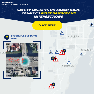
SW 127th St / SW 56th Ave:
This mixed-use area experiences a constant influx of traffic, both vehicular and pedestrian. Severe braking events are concentrated in a specific lane, suggesting a lane reduction as a factor. The presence of a pedestrian crossing adds another layer of complexity, compounded by limited visibility due to trees and a nearby bus stop.
SW 232nd St / SW 147th Ave:
SW 232nd St and SW 147th Ave present unique challenges in a rural setting. The high frequency of severe braking events points to the need for signage and improved lane markings. Heavy traffic, multiple private estate entrances, dense foliage, and the absence of pedestrian crossing signage all can be contributing to heightened risk.
SW 8th St (US Highway 41) / SW 97th Ave:
This intersection stands at the crossroads of complexity, with historical crash data underscoring its danger. Severe braking events concentrated in the northwest lane raise concerns, particularly regarding vulnerable road users, lane reductions, bus stops, and visibility. The transition from high-speed zones to an intersection with pedestrian activity amplifies the challenges.
Embracing the Future of Road Safety
The fusion of AI and data analysis marks a new dawn in road safety assessment. By deciphering behavioral patterns and anticipating risks, we can avert crashes and save lives. The meticulous analysis of Miami-Dade County’s risky intersections through the lens of severe braking events demonstrates the power of our innovative approach. As we continue to refine and expand our methodology, we are forging a path toward a safer and more secure driving experience for all.