Outline
- Zero Deaths do Exist
- Road Safety Projects already on the Go
- A Closer Look at Section 24112, Safe Streets and Roads for All
- How Driving Data Supports a Safe Streets and Roads for All Application
- Take Full Advantage of SS4A for Your Road Safety
Section 24112 of the Infrastructure Bill, Safer Streets and Roads for All (SS4A), offers $5 billion over five years in local initiatives to prevent death and serious injury on the road. This series of grants focuses on vastly improving road safety through analysis, drawing on data and embracing the adoption of innovative technologies and strategies. A Safer Streets and Roads for All grant application that includes driving data can help grant funds go farther. DOTs maximize their investment – and their impact on road safety.

Zero Deaths do Exist
Before studying the SS4A program in detail, let’s take a quick look at road safety activity that’s already happening around the country. To start, the city of Hoboken, NJ, has had six calendar years since 2009 without a road death. In Lakeville, MN, they’ve had three calendar years without a traffic fatality. In Sammamish, WA, they’re up to nine years. In fact, there are 239 cities of 50,000 people or more around the United States who have had anywhere from one to ten years since 2009 without a road death. Vision Zero in action!
Source: https://www.dekra-vision-zero.com/map
Road Safety Projects already on the Go
For some further inspiration, here are a few examples of current projects that support Vision Zero initiatives, announced between April and May of this year.
- PennDOT awarded $54.1 million to support, among others, on- and off-road pedestrian and bicycle facilities, infrastructure projects that improve access to public transportation and safe routes to school projects.
- In Ohio, $51 million is being invested in projects that specifically target traffic crashes involving pedestrians and fatal roadway departures on both state and local roads.
- Tampa has added 5 miles of bike lanes on Davis Islands, lowered speed limits, raised crosswalks and added flashing signals to them, and implemented new four-way stops.
- As for the Illinois Department of Transportation, it gave $12.3 million for 57 local safe routes to school. Governor J.B. Pritzker noted during the announcement, “Strong infrastructure is as much about bike paths and sidewalks as it is about highways and freight trains.”
- In Orlando, Florida, collaboration is how it’s done. Members from city, county, region and state entities meet, including educational establishments, airports and road authorities. They understand what funding is available, and what applications focus on. They then focus on key topics and rank them according to potential impact and overall difficulty of implementation.
- Finally, in Syracuse, NY, data is used to remove snow from sidewalks and target repair. Pedestrians stay safe on their journey, instead of having to detour onto the road when the sidewalks can’t be used. Corey Dunham, the city’s Chief Operating Officer who runs the program, comments, “There are so many decisions we have to make with limited resources. It helps me to sleep better at night to know that I can defend the decisions we’ve made because they’re supported by data.”
Sources: https://aashtojournal.org/2022/04/29/state-dots-funding-local-safety-mobility-projects/ /https://bloombergcities.jhu.edu/news/cities-use-innovation-get-smarter-about-infrastructure // https://thatssotampa.com/vision-0-davis-island-tampa/
A Closer Look at Section 24112, Safe Streets and Roads for All
Now there’s the Safe Streets and Roads for All program in the Infrastructure Bill. A new opportunity to reduce traffic fatalities and serious injury on your transportation network. There are two aspects about the Program that are important to take into account.
Comprehensive Road Safety Action Plan Required – Vision Zero
The SS4A program wants to know what exactly is being funded, and that a strategy is in place to prevent car crashes that result in death. As part of the road safety action plan, states and localities need:
- to know the locations where safety is at risk in their transportation system
- to know how great the risk is at each of these locations
- data to back up observations and identify strategies to deal with the identified road safety problems
- to be able to evaluate the outcomes and effectiveness of the comprehensive safety action plan – including reporting to residents.

Eligible Road Safety Projects Apply New Technology and Cover the Full Network
The Safe Streets and Roads for All program emphasizes results that incorporate new technology and strategies to improve road safety. Eligible projects are those that are considered likely to significantly reduce or eliminate car crashes leading to deaths or serious injury involving various users (pedestrians, cyclists, motorists, public transportation and commercial vehicles). They seek to adopt innovative technologies or strategies to promote safety. And they employ low-cost, high impact strategies that can improve road safety over a wide geographical area.
How Driving Data Supports a Safe Streets and Roads for All Application
Michelin DDi can accompany you in your request for Infrastructure Bill funding. Our innovative and accessible technology focuses on and analyzes driving behavior in three ways.
#1 Capture Driving Events
At the first level, the technology captures and measures the intensity of driving events such as harsh braking, harsh acceleration, excessive speeding … After aggregating and contextualizing, this driving data can be consulted and analyzed in any GIS (geographic information system), and filtered according to weather conditions, time of day, day of the week…
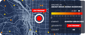
#2 Identify Near Miss Hotspots
Once driving events have been detected and located, near miss hotspots can be identified, assessed and ranked according to where safety risks are most severe. Priorities can be set as to where and how to focus safety efforts to have the greatest impact.
#3 Define Crash Probability
Finally, different sources of data (such as driving events, historical crash data, traffic and contextualization) can be processed using a model built with machine learning and artificial intelligence to produce crash probability indicators throughout your transportation network. All locations where road safety is most compromised are revealed. You can apply your expertise to managing in detail all locations where safety actions will have major and positive repercussions.
Take Full Advantage of SS4A for Your Road Safety
For a Safe Streets and Roads for All grant application, you can, for example,
- Identify locations and their severity across a wide geographic area, your full transportation network
- Identify strategies to improve road safety
- Measure outcome and the effectiveness of implemented safety initiatives
- Report before-and-after results to local residents and government agencies
Michelin DDi’s low-cost, high impact driving data solutions provide the depth of knowledge and actionable insights you need to maximize the funds you receive from the government, as well as their effectiveness and utility on your roads. You have the facts to support where exactly investment is required, what investment is required, and that it will lead to safer roads for all users on your transportation network.
With two years of driving data to draw on, complement your crash data with recent, accurate and explicit facts about safety concerns on your roads.